Smog is dangerous for everyone. We monitor air pollution and simulate its spread.
Fogees is a state-of-the-art application that enables an accurate analysis of air pollution in a given area. Measurement data is presented in real time, facilitating response and decision-making.
The application allows the assessment of the role of each emission source in the context of the overall result. You can create various scenarios (e.g. furnace replacement) and test their environmental impact without any risk to the health of residents.
At the heart of Fogees is an advanced mathematical model, developed in collaboration with scientists from the ATH University of Bielsko-Biała. Thanks to it and the artificial intelligence system, the data in the simulations is extremely accurate. It takes every detail into account and identifies correctly its relevance to the climate situation.
Fogees works in two areas: the presentation of current pollution levels and the simulation of smog spread.
For both these purposes, the system uses numerous data sources: readings from pollution sensors and weather stations, weather forecasts, altitude models, landform data and low-stack emissions data.
Fogees is an excellent tool for institutions managing environmental protection over a larger area: municipalities, housing associations, property developers, etc. It allows them to identify the most dangerous sources of emissions, recommends actions to reduce pollution levels and allows them to create reliable simulations of the effects of specific changes.

Contact us and join the Fogees software trials.
Fight for air quality with proven data.
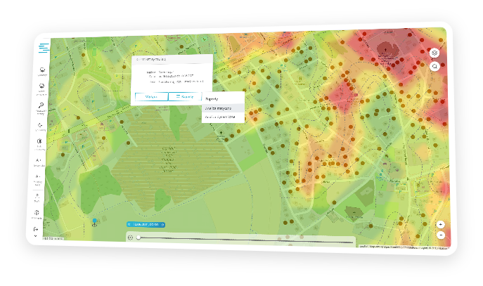
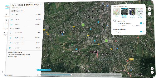
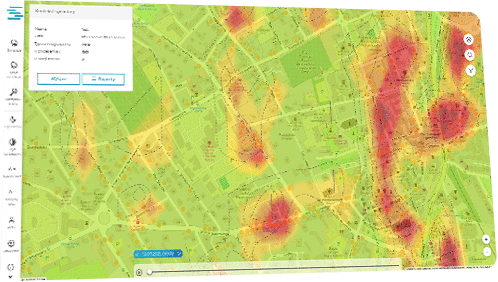
Fogees is able to present very precise data on the current air pollution levels – indicating the current smog intensity, triggering the relevant alert, presenting the history of changes on a timeline, etc. This information can then be made available as 2D or 3D visualisations and presented to the public (on a dedicated portal or on residents’ mobile devices).
The main advantage of Fogees, however, is the preparation of reliable simulations of smog spread and changes in the climate situation. Users receive a detailed report, including information on the geometry, direction of movement and intensity of the pollution cloud in the future. The simulation also makes it possible to predict the effects of changes in the number or capacity of low-stack emission sources. The investor will therefore be able to estimate which variant of a development project or, for example, furnace replacement will be optimal.
Fogees is compatible with most commercially available devices for tracking air pollution levels and measuring weather indicators. It can therefore be used as a system that integrates all the sensors previously owned by the investor and combines the data provided by them into a coherent whole.
Watch a few minutes of video and see how Fogees works in practice
Great works are created slowly. Fogees is a well-thought-out system, developed
and checked carefully by both programmers and scientists.
Conceptual work
Start of project implementation
Work on the project’s proprietary mathematical model
Implementation of the model and development of a mechanism to collect data from multiple sources
Verification and validation of the mathematical model for the calculation of particulate matter (smog) concentrations
Testing of a prototype system for pollution prediction in urban areas using the mathematical model
Zapisz się do newslettera i otrzymuj wiadomości o nowościach
związanych z programowaniem Fogees

Leave your contact details and take part in a presentation of the Fogees system
There is also the possibility of an individual presentation of the system outside the appointment list.
| Basic | Extended | Max | |
|---|---|---|---|
|
Map view – current situation and 24/48h forecast |
YES +24h |
YES +24h |
YES +48h |
|
Integration with existing weather stations and air quality sensors * |
YES |
YES |
YES |
|
Summary information on current readings from weather stations
and air quality sensors * |
YES |
YES |
YES |
|
Visual representation of readings from weather stations and air quality sensors * on a map + history 1 day back |
– |
1 day back |
7 day back |
|
Website widget (plug-in) |
Plain (text) |
Full (graphic) |
Full (graphic) |
|
Smog cloud simulations – access to building base and road network |
– |
– |
YES |
|
Smog cloud simulations – access to historical weather forecasts |
– |
12 months |
36 months |
|
Smog cloud simulations – computing grid |
– |
4x4kmfixed |
0,5×0,5kmadjustable |
|
Smog cloud simulations – number of simultaneous calculations and priority in the cloud
|
– |
1 / normal |
3 / high |
|
Smog cloud simulations – number of historical user reports remembered |
– |
3 |
4+ |
Find answers to the most common questions
Fogees is an innovative application for forecasting, monitoring and generating analyses based on air pollution levels from a set area. Fogees is a system that provides information on the actual and simulated level of smog spread through the use of a proprietary mathematical model developed as part of the ‘Silesia under the Blue Sky’ project implemented with funds from the Smart Growth Operational Programme 2014-2020.
The application’s functionalities provide such options as: forecasting the spread of air pollution (smog), taking remedial action to reduce low-stack emissions, creating an effective database of possible hazards, providing early warnings of air pollution alert levels to residents, generating reports and analyses to determine optimal directions for combating the smog phenomenon.
The application is intended both for local government units responsible for measures to reduce pollution levels in a given area and for citizens who can track the condition of the atmosphere, for example, at their place of residence. The application can also serve as a tool providing a range of analyses and simulations for environmental audits.
We want to reach as large an audience as possible. However, due to the wide variety of mobile devices, we have decided on a solution to access Fogees from any web browser, both on a computer and on mobile devices.
The Fogees application, among other things, allows the spread of smog to be simulated by applying a proprietary mathematical model to a selected area. For this to be possible, specific input data is required:
(a) landforms, elevation model
(b) roughness of the terrain, buildings, road structures
(c) selected information on sources of low-stack emissions
(d) weather forecast data
(e) data from pollution sensors and weather stations
Within the Fogees application, a universal mechanism has been developed to collect data from multiple sources. The application includes the option of integration with any equipment manufacturer, provided that the manufacturer has foreseen such an option for, among other things, measuring pollution levels and meteorological parameters. For the purposes of the system, integration with selected equipment suppliers in Poland has been tested.
The basic assumption of Fogees is to comprehensively support customers in their ongoing tasks related to their efforts to improve air quality. Nevertheless, if such a one-off service is required, our system is of course prepared to provide such simulations.
Trial access is planned as one of the forms of getting familiar with the features of our product. We are working intensely to launch the application with trial access.
The mathematical models of the air velocity field and pollutant dispersion included in the Fogees application are an integral part of the pollution forecasting system. The diagnostic model used to calculate the air velocity field is based on a method of interpolating data (diagnostic model): either measured data, from weather stations, or data from detailed global numerical weather prediction models. A proprietary implementation of the variational algorithm was used to interpolate the data.
The dispersion model is a modification of the Lagrangian particle model, which belongs to the group of numerical models. It is worth emphasising here that the Lagrangian model of particle motion applied enables the use of parallel computing techniques.
An innovative technical solution applied in Fogees is the use of a continuous form of the surface description function, allowing the simultaneous description of the landform along with the height of the buildings. Due to the discretisation mesh with inequidistant nodes used in both computational models (air velocity field and pollutant dispersion), the models can be applied both to spatial micro- and mesoscale. In a highly urbanised area, it is possible to use a discretisation mesh with smaller distances between nodes, allowing an accurate representation of the analysed area. In contrast, where a high degree of mapping is not required (e.g. farmland, woodland), the distances between nodes can be greater. The use of such an approach to air pollution modelling also makes it possible to reduce the time needed to develop pollution forecasts and to calculate pollutant concentrations more accurately in an area with complex topography.
W celu świadczenia usług na najwyższym poziomie stosujemy pliki cookies, które będą zamieszczane w Państwa urządzeniu (komputerze, laptopie, smartfonie). W każdym momencie mogą Państwo dokonać zmiany ustawień Państwa przeglądarki internetowej i wyłączyć opcję zapisu plików cookies. Ze szczegółowymi informacjami dotyczącymi cookies na tej stronie można się zapoznać w naszej polityce cookies.
Tutaj możesz dostosować swoje preferencje odnośnie cookies
Niezbędne pliki cookie umożliwiają podstawowe funkcje i są niezbędne do prawidłowego funkcjonowania strony internetowej.
Szczegółowe informacje nt cookies znajdują się w polityce cookies Pliki cookies